

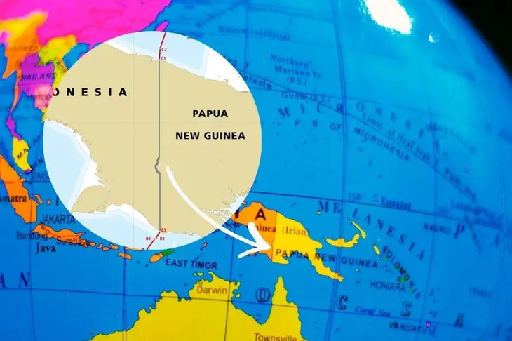
On most world maps, the border between Indonesia’s region and Papua New Guinea appears as a firm, straight line running north to south along the 141st meridian east. But look closer, and you will notice a subtle curve interrupting that geometric precision.
That bend is not accidental. It is the story of two rivers, the mighty Fly River and the lesser-known but symbolically powerful Torasi River, whose waters have shaped diplomacy, geography, and daily life on the island of New Guinea.
A Giant That Refused to Be Ignored
The Fly River is one of the largest and longest rivers in the South Pacific. Stretching more than 1,000 kilometers through dense rainforest and lowland swamps, it has long served as a lifeline for communities in southern Papua New Guinea.
When colonial powers, particularly the Netherlands and Great Britain, negotiated territorial boundaries in the late 19th century, they preferred clean, mathematical lines. The 141° east longitude was chosen as a convenient divider between western, then Dutch territory and the British-controlled eastern Papua.
But the Fly River complicated that simplicity, rather than slicing directly across such a massive and navigable waterway, early surveyors adjusted portions of the boundary near the river’s upper reaches. Practical geography overruled cartographic perfection. Rivers were visible, navigable, and meaningful to local populations, far more tangible than imaginary lines drawn across unexplored forest.
The result, a small but noticeable deviation from the straight meridian, a reminder that nature sometimes negotiates better than diplomats.
A Quiet Marker of Sovereignty
Further south, near the coastline close to the Arafura Sea, the Torasi River plays a quieter yet equally significant role. Unlike the vast Fly River, the Torasi is modest in scale, but its location, precisely along the international boundary, gives it geopolitical importance. For Indonesia, the Torasi River marks one of the southernmost natural reference points of its eastern frontier.
In border management and bilateral cooperation between Indonesia and Papua New Guinea, the Torasi River area often represents:
- A point of cross-border interaction
- A reference for territorial demarcation
- A symbol of peaceful coexistence between neighboring communities
Where the Fly River shaped historical boundary negotiations, the Torasi River represents modern border stewardship,including trade, security coordination, and cultural exchange.
Where Nature Meets Diplomacy
The Indonesia – Papua New Guinea border teaches an important lesson: borders may be political decisions, but landscapes shape how those decisions endure.
The Fly River’s vast basin made it impractical to ignore. The Torasi River provided a natural anchor at the coast. Together, they illustrate how rivers influence sovereignty, settlement patterns, and international relations.
Today, the Indonesia – Papua New Guinea boundary remains largely peaceful, with growing cooperation in trade, infrastructure, and environmental protection. Yet its slight curve, born from the presence of a powerful river system, stands as a subtle geographic signature of history. In the end, the story of the Indonesia – Papua New Guinea boundary is not merely about longitude lines. It is about water. The Fly River flows wide and commanding, shaping negotiations more than a century ago. The Torasi River flows quietly, anchoring the present. Together, they remind us that in West Papua rivers do more than connect landscapes, they shape nations.
